RETURN TO LAWRENCE, MASS. PAGE
Elm Street, Lawrence, Mass.
Sketch of Elm Street, 1930s to '40s
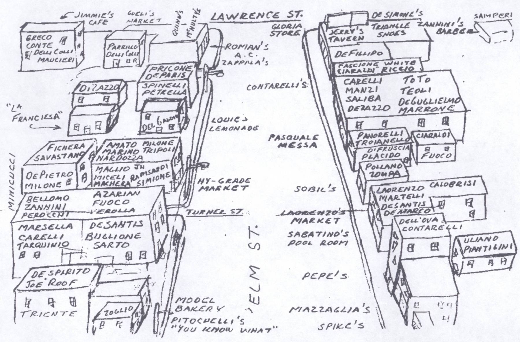
| | John Piantigini's Map (click for large view) |
John Piantigini of Methuen, Mass., in 2007, provided this map which had been prepared some years before with the assistance of
"old timers" who remembered the old neighborhood.
Sanborn Map, 1911
The Sanborn Map Company produced, starting in 1867, highly detailed maps of American cities. The maps show every building
on every street, with details regarding construction and use that would aid insurance companes in setting rates. The diagram below
is based on a scan from a microfilmed Sanborn Map from the Massachusetts State Library. Details have been omitted im order
to make room for the names of the families living on the street.
To view the detailed scan click here.
For each building on the street the street number is show and is a link to details about that building, when available.
For several of the buildings I have indicated the occupant (family or shop) with links to details where available.
|
|
|
|
|
|
|
|
|
|
|
239 Louis' Pool Hall
|
|
|
|
235 Silverstono's Bakery
|
|
|
|
231A (shop) A. DiZazzo (1922-1925)
|
|
|
|
231
|
|
232 (off alley) A. DiZazzo (1924-1945)
|
|
229A
|
|
230
|
|
229
|
|
224
|
|
223
|
|
220 (off alley) A. DiZazzo (1917)
|
|
221 (off alley)
|
|
218
|
|
219 (off alley) R. DiZazzo (1930-1939)
|
|
216
|
|
217
|
|
214 (off alley)
|
|
215
|
|
30 Turner St. (co. alley)
|
|
213
|
32 A Turner St.
32 B Turner St. (co. Elm)
|
|
211 Sobil Dry Goods Store
|
|
|
|
209 (off alley)
|
|
|
|
207 (front)
|
|
23 Turner St.
|
|
205 (middle) J. DiZazzo (1930)
|
|
208
|
|
203 (rear) Sabatinos' Pool Hall
|
|
|
|
|
19 Turner St.
|
|
|
|
200
|
|
201 Pepe's Pool Hall
|
|
17 Turner St.
|
|
199-1/2 (rear) Piantiginni
|
|
|
199
|
|
196
|
|
197A
|
|
|
|
|
|
15 Turner St.
|
|
197B
|
|
194
|
|
|
|
|
|
|
|
13 Turner St.
|
|
195
|
|
|
|
193 A. DiZazzo (1907)
|
|
|
|
|
|
11 Turner St.
|
|
|
|
190
|
|
189B
|
|
189
|
|
|
|